

Distribution
Rainbowfishes are one of the most speciose groups of freshwater fishes inhabiting the Australia-New Guinea region. Australia lies between latitudes 10°41’S (Cape York) and 43°39’S (South East Cape, Tasmania) and between longitudes 113°09’E (Steep Point) and 153°39’E (Cape Byron). The latitudinal distance between Cape York and South East Cape, Tasmania is 3,680 km. The longitudinal distance between Steep Point and Cape Byron is about 4,000 km. With a total land area of 7,682,000 km2, it is the lowest, the flattest and, with the exception of Antarctica, the driest of the continents. The continent has a wide range of climatic zones, from the tropical regions of the north, through the arid expanses of the interior, to the temperate regions of the south. Seasonal fluctuations can be great, with the temperatures ranging from above 50°C to well below zero. The continent often experiences natural disasters, particularly droughts, floods, tropical cyclones and bushfires.
Australia, the world’s sixth-largest country, is an isolated continent, with the Indian Ocean to the west, South Pacific Ocean to the east, and Southern Ocean to the south, but with New Guinea and Southeast Asia just to the north. The birth of Australia began soon after the dinosaurs disappeared, 65 million years ago. It was the last landmass to split away from the ancient southern super-continent Gondwana. The world’s continents were once all joined in a single landmass called Pangaea. In the Jurassic period (about 160 million years ago) a northern continent, Laurasia, and a southern continent, Gondwana, split apart. The exact nature of the break-up of Gondwana is not understood with precision, but it gradually fragmented over geological time, with India and then New Zealand moving away from the AustraliaAntarctica-South America group during the Cretaceous period (140 million years ago). The latter group of continents separated from each other during the Tertiary period (from about 70 million years ago).
It took many millions of years for Australia and Antarctica to fully separate, with Tasmania caught in the middle. But finally, about 40 million years ago, they parted and commenced a northward drift. Australia dragged Tasmania north, leaving Antarctica alone at the bottom of the world. With Australia out of the way, ocean currents were free to circle the South Pole, as they still do today, greatly influencing the world’s climate.
During this time, Australia experienced numerous changes in climate, but the overall trend was towards greater aridity. The great inland seas and lakes dried out. Much of the longestablished broad-leaf deciduous forest began to give way to the distinctive hard-leaved sclerophyllous plants that characterise the modern Australian landscape. For many species, the primary refuge was the relatively cool and wellwatered Great Dividing Range. Even today, pockets of remnant vegetation remain in the cool uplands, some species not much changed from the Gondwanan forms of 60 or 90 million years ago.
New Guinea began to form then, along the northern edge of the Australian continental plate, developing in two parts. One part was the northern rim of the Australian plate itself and the other a string of islands off the north-east coast, away from Laurasia. The islands and mainland only came together towards the end of the Tertiary, forming the high and rugged mountains and giving New Guinea its present form. That process is on-going, with some mountains having now reached 4,884 metres ASL in little more than 3 million years since the beginning of the accelerated uplift. This had a number of important consequences, including the formation of the New Guinea highlands, and providing an opportunity for the dispersal of Asian taxa to the now relatively close Australia, and similarly for Australia taxa to emigrate. New Guinea’s proximity to the Sunda Shelf and many islands may well have provided a stepping-stone for taxa to move between the two worlds. The Sahul Shelf, constituting Australia, Tasmania, New Guinea and adjacent islands, possibly including Halmahera Island, has continued on a northward path ever since. New Guinea itself should be considered part of greater Australia, because for a great deal of its history it has been part of the Australian mainland (as has Tasmania).
The Sahul Shelf is a structural platform of the ocean floor and is bounded to the northeast by a series of deep-sea troughs and to the northwest by troughs, a chain of coral reefs, and a series of submarine ridges. The Sahul Shelf was once above sea level, and its surface still bears erosional features formed when streams crossed it to the oceans. The shelf was slowly warped downward by crustal forces. This subsidence is evidenced in coral atolls along its edge, composed of coral that grew as the land sank. The shelf’s main divisions are the shallow Arafura Shelf, covered by the Arafura Sea and Gulf of Carpentaria; the Sahul Shelf under the Timor Sea; and the Rowley Shelf underlying a part of the northwest Indian Ocean extending to North West Cape, Western Australia. To the north lay the deeper Timor tough and the volcanic Lesser Sunda Islands, separating the Sahul from the Sunda Shelf.
Australia and New Guinea have been alternately land-linked and separated by water on a number of occasions over millions of years. The alternating global warming and cooling episodes of the last three million years repeatedly isolated then reconnected New Guinea and Australia, as the Arafura plain successively submerged and emerged with changing sea levels. Global sea levels are currently higher than at anytime during the last 120,000 years, separating Australia and New Guinea by sea. However, Torres Strait has been acting almost consistently as a land-bridge since the last interglacial about 118,000 years ago up until 6~8,000 years ago, when marine transgression closed the bridge. About 12,000 years ago, sea levels were low enough that the Arafura Shelf was exposed, and 20,000 years ago, sea levels were 120 metres below present levels. The water barrier, which is now the Arafura Sea, Gulf of Carpentaria, and Torres Strait, which separates Australia and New Guinea are extremely shallow, with average depths ranging from about 15 to 60 metres.
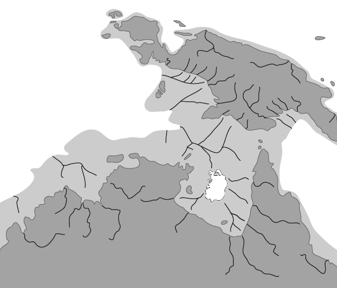
Voris (2000) hypothesised that a large ancient river system existed at times of lower sea levels that linked major rivers in southern New Guinea to northern Australia. There is also evidence to suggest that throughout much of the Pleistocene, a large freshwater to brackish water lake (Lake Carpentaria) formed in what is today the Gulf of Carpentaria. Lake Carpentaria was a large (~30,000 km2) inland lake. Not only did Cape York Peninsula provide a land link between New Guinea and north-east Australia, but also Lake Carpentaria would have provided a freshwater aquatic link. The lake would have been fresh or brackish for much of its existence. Evidence from deep core drilling reveals a pattern of establishment and marine inundation of Lake Carpentaria that appears to have been repeated. It was a freshwater lake in the Jurassic then inundated by a marine transgression (in limestone deposits), and there was a further freshwater episode in the Miocene, followed by another marine transgression. As the sea levels rose, this lake disappeared. One reminder of this ancient lake is the current fragmented distribution of rainbowfishes such as Iriatherina werneri and Melanotaenia maccullochi in rivers of Arnhem Land, Cape York and southern New Guinea. The fish species of the mid-Peninsula rainforests also have a strong affinity with New Guinea. The Olive and Jardine rivers show some of the strongest relationship, with 81% and 63% of the fish species found in these rivers being common between the two countries.
There is convincing geological evidence for the historical existence of Lake Carpentaria. Moreover, it has been suggested that the outflow of Papua New Guinea’s Fly River was diverted westward into Lake Carpentaria during this period, although this hypothesis is still controversial. Harris et al. (1996) found no evidence for a past westward diversion of the Fly River, and suggested that the outflow of the river in ‘recent’ geological time has always remained on an easterly course into the Coral Sea. However, the hypothesis that Lake Carpentaria provided habitat for, and facilitated the distribution of aquatic species during the late Pleistocene is supported by recent studies.
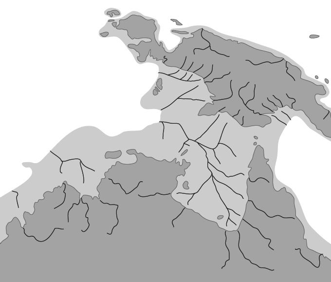
Evidence suggests that past fluctuations in sea level have influenced the genetic structure of a number of terrestrial and aquatic species across northern Australia and New Guinea. A close genetic relationship between rainbowfishes and other aquatic species such as freshwater shrimp (e.g. Caridina and Macrobrachium) and crayfish (Cherax) from northern Australian and populations in New Guinea has been observed (McGuigan et al. 2000; Unmack 2001; de Bruyn et al. 2004; de Bruyn & Mather 2007; Page et al. 2007; Baker et al. 2008). A hypothesis for two independent colonisations of rainbowfishes into Australia from New Guinea was based on monophyletic relationships among Australian and southern New Guinea rainbowfishes. McGuigan et al. (2000) suggested contemporary distributions of rainbowfishes reflect episodic connections via the ancient freshwater Lake Carpentaria during periods of low sea level when routes for dispersal from New Guinea to northern Australia were present.
Cape York Peninsula provided the main land link, but a second land link between Arnhem Land and New Guinea formed at much lower sea levels. This made possible the movement of plants and animals so that a potential biological ‘bridge’ existed between the continent and subcontinent with a wide plain across what is now the Arafura Sea. The only high ground on the plain were low hills that are now islands fringing the Kimberley coast and Arnhem Land, the islands in Torres Strait and the low hills that fronted the north-western coastline of the Arafura Plain (now the Aru Islands). Major river systems flowed across this plain, arising from both the south and the north. The plain had vast shallow lakes, and embayments fringed with mangroves and salt-marsh. Rainforests were largely confined to the mountains and slopes to the north and to riparian zones and protected gorges in the south, with much of the Arafura Plain a savannah, similar to parts of northern Australia today.
The connections were especially strong, close and more enduring between Cape York Peninsula and southern New Guinea. There are several plant and animal species, which only occur on Cape York Peninsula and in New Guinea.
Plants, birds, reptiles, and mammals with this distribution are largely found in the northern half of the Peninsula and reach their greatest diversity in the mid-Peninsula rainforests. The rising sea also fragmented the range of many other plants and animals. Comparable environments and species assemblages persist in the TransFly, Port Moresby and Popondetta regions of Papua New Guinea, and across northern Australia.
The current distribution of a number of northern Australian and southern New Guinea rainbowfish species can be explained by the opportunities the lake and the exposed Arafura Shelf provided. The Arafura Shelf that defined the western boundary of Lake Carpentaria would also have provided a land-bridge to New Guinea presumably with drainages flowing west to the Timor Sea. This would have allowed potential interchange of forms between West Papua, Arnhem Land and the Kimberley via coastal rivers and associated habitat quite different from that provided by Lake Carpentaria. It would also have isolated the rainbowfish fauna from these western and west-central rivers from those flowing into the eastern seaboard of Australia and south-eastern New Guinea. This may explain the different species found in the Kimberley and western Arnhem Land.
Unfortunately, no rainbowfish fossils exist so their evolutionary history will probably remain obscure. However, there is some belief that rainbowfishes probably originated in the north of Australia, or in southern New Guinea and then spread eastward, north into New Guinea and southward down the northeast coast of Australia, differentiating into the various species we know today. In south-eastern Australia, the primary driving force behind current rainbowfish distributions appears to be climatic.
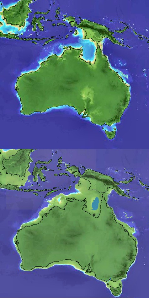
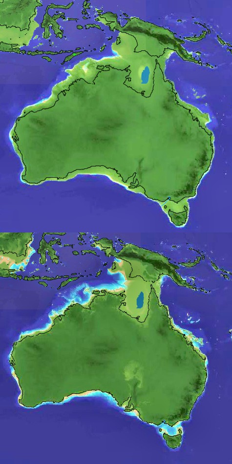
These maps show the changing shape of Australia and New Guinea that mimics the rise and fall of sea levels over the past 10,000~50,000 years. The green sections of the map indicate dry land. It was during such periods that rainbowfishes were dispersed between Australia and New Guinea. See Temporal Earth https://temporalearth.org/
Many factors affect the distribution of rainbowfishes but one of the most important is biogeographical boundaries. As far as rainbowfishes are concerned, the most important biogeographical features are the drainage division boundaries.
There is a very high degree of endemism in the Australian freshwater fish fauna that corresponds to current drainage divisions, and where fish species are shared among divisions, this allocation is usually explained by high drainage connectivity during periods of lowered sea level (Voris 2000; Unmack 2001) or possibly due to ancient river capture events.
Riverine landscapes can change in a number of different ways. For example, when sea levels are low, rivers may coalesce before reaching the sea, whereas when sea levels are higher, rivers may flow independently into the sea. The result is that populations that were historically isolated may become connected, and some connected populations may become isolated.
Natural river capture events can be the result of movement in the earth’s crust or just the simple process of one stream eroding back and cutting into the headwaters of another stream – capturing part or the entire stream. River capture can also create waterfalls. River capture may have been involved in the interdrainage transfer, vicariant isolation, or cladogenesis in some Australian rainbowfishes, isolating populations that previously inhabited the same system.
The Great Dividing Range is one of Australia’s most important geographical features. The range runs parallel to the east-coast of Australia, from Cape York in the north to western Victoria in the south. Tasmania, Australia’s island state which lies even further south, is also a part of this massive and ancient mountain range.
Before the formation of the Great Dividing Range, it is hypothesised that no mountains existed along the whole eastern side of Australia. At that time a gently rolling plain with moderately sized hills stretched from New Guinea to Tasmania. Then a huge uplift in the earth’s crust occurred over millions of years creating the Great Dividing Range and causing the rivers in the region to flow both east to the sea, or west and inland. It was probably being formed when ancestral rainbowfishes were already established in inland and coastal rivers systems. Thus the Great Dividing Range has loomed large in the evolution of both Australian rivers and native freshwater fish species.
Many aquatic species that would have previously had a much wider distribution were isolated in catchments east and west of the Great Dividing Range. Over many thousands of years, this isolation meant that species evolved independently and this led to many variations in species. The influence of this vicariant factor in evolutionary diversification is supported by findings of marked genetic and phylogeographic structure between coastal and inland populations of several Australian freshwater fish. In some cases, fish populations have been designated as separate species, such as Melanotaenia duboulayi and Melanotaenia fluviatilis.
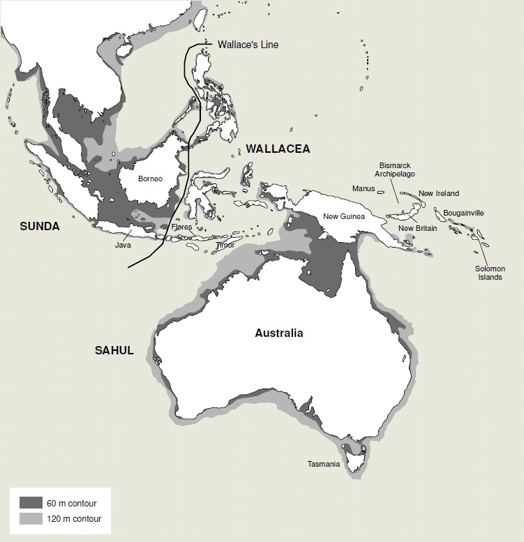
It is important to note that biogeographical boundaries do not necessarily correspond with governmental boundaries. The western half of New Guinea is the Indonesian province of (West) Papua. However, Indonesia is part of the Asian continental plate and was, until 20 million years ago, well separated from Australia and New Guinea.
The Indonesian archipelago spans two major biogeographical regions divided by Wallace’s Line. West of this line lies the Indo-Malayan region, which includes the islands of Java, Borneo and Sumatra on the Sunda Shelf; to the east lies the Australasian region. Wallacea is a biogeographical designation for a group of Indonesian islands separated by deep water straits from the Asian and Australian continental shelves. Wallacea, comprising the Lesser Sunda Islands, the Moluccas and Sulawesi, has had no recent land connection to either continent.
The islands of the Sahul Shelf which include Waigeo, Batanta, Salawati and Misool to the west; Aru Islands to the south; and Japen to the north in Cenderawasih Bay all had recent intermittent land connections with mainland New Guinea. Those which lie off the Sahul Shelf had no connections with New Guinea in the recent past.
Although the region today includes two very different nations and part of a third, and although the two main landmasses are currently separated by Torres Strait, from a biological and geological point of view, it is a single unit. Most of the fauna and flora of New Guinea are shared, at least in their origin, with the continent of Australia. While much of the rest of the world underwent significant cooling and thus loss of species diversity, Australia–New Guinea was drifting north at a pace such that the overall global cooling effect was roughly equalled by its gradual movement toward the equator.